Montgomery County Trolley Map
Click on this map to access the full-size
version. (Note: the full-size map is a 334K download.)
Map © 2002 by Mike Szilagyi
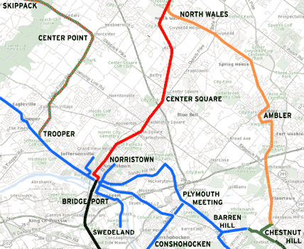 This
map shows the trolley network that linked most of Montgomery County, in the
first half of the twentieth century. The legend in the lower left hand corner
(of the full-size map) lists the dates the trolley lines were completed, and
when they were abandoned.
This
map shows the trolley network that linked most of Montgomery County, in the
first half of the twentieth century. The legend in the lower left hand corner
(of the full-size map) lists the dates the trolley lines were completed, and
when they were abandoned.
For example, the brown line on this
map, known in later years the Skippack and Perkiomen Transit Company,
stopped running in 1925.
The blue lines, known as the Reading Transit Company,
converted to all buses in 1933.
The red line, the Liberty
Bell high speed line, quit in 1951.
Articles about three of these trolley systems can be accessed at the Norristown
Trolley page.

